2025-06-30 09:27 PM: Remove a
redundant picture
@@ -111,8 +111,6 @@
-[](PXL_20250621_212844849.jpg)
-
2025-06-30 02:16 AM: Fix two typos
@@ -28,7 +28,7 @@
-With all the rain I learned a few ways that I can improve the waterproofing of our equipment! In particular the supposedly waterproof compression bags that contain out summer sleeping bags are definitely not waterproof, and I threw a few things in my bag at the last minute that I completely failed to protect from water. Fortunately it mostly stopped raining after we got there, and the wind helped everything important dry relatively quickly, and the truly waterlogged items were not vital.
+With all the rain I learned a few ways that I can improve the waterproofing of our equipment! In particular the supposedly waterproof compression bags that contain our summer sleeping bags are definitely not waterproof, and I threw a few things in my bag at the last minute that I completely failed to protect from water. Fortunately it mostly stopped raining after we got there, and the wind helped everything important dry relatively quickly, and the truly waterlogged items were not vital.
@@ -104,7 +104,7 @@
-So out choices were to either head home now (adding an another day's worth of paddling to today's itinerary), or wait until tomorrow and risk one of the following happening:
+So our choices were to either head home now (adding an another day's worth of paddling to today's itinerary), or wait until tomorrow and risk one of the following happening:
2025-06-28 04:11 AM: Edits for
wording/clarity
@@ -4,17 +4,17 @@
-The idea was to arrive on Friday in the early afternoon and spend the first night at Togue Ledge campsite, the closest camp site to the canoe launch at about 1.75 miles away. Then Saturday morning we could head about 4.5 miles further down the lake to Pine Point, and hopefully have time to explore down the lake to Webster Brook. Then Sunday we'd paddle the 4.5 miles back, maybe checking out the part of the lake around Hay Brook along the way if we felt up to it.
+The idea was to arrive at Trout Brook Campground Friday in the early afternoon, rent a canoe and spend the first night at Togue Ledge campsite, the closest camp site. Then Saturday morning we could head about 4.5 miles further down the lake to Pine Point, and hopefully have time to explore down the lake to Webster Brook and the East Branch of the Penobscot River. Sunday we'd paddle the 4.5 miles back, maybe checking out the part of the lake around Hay Brook along the way if we felt up to it.
-Unfortunately at the last minute the forecast took a turn for the worse, with the forecast at the park predicting probable rain the afternoon we got there, and a thunderstorm possible on the morning of our last day. I felt we'd be OK waiting out a storm at the campsite in the morning, but wouldn't want to get stuck for an extra night if the thunderstorms hit later than predicted. In the past I would not have had any way to get an updated forecast in the park (which does not have cell coverage), so I might have cancelled the whole trip with that much uncertainty, but last year I got a [Garmin inReach Mini 2](https://www.garmin.com/en-US/p/765374/) on sale. I got the minimal model because I really only wanted it for the emergency SOS feature, but I can also use it to get detailed weather forecasts via satellite, so we could always check it and decide whether to leave a day early during the trip.
+Unfortunately at the last minute the forecast took a turn for the worse, with rain and wind when we got there, and a thunderstorm possible on the morning of our last day. I felt we'd be OK as long as things didn't get worse. In the past I would not have had any way to get an updated forecast. There's no cell coverage in the park, so I might have cancelled the whole trip with that much uncertainty, but last year I got a [Garmin inReach Mini 2](https://www.garmin.com/en-US/p/765374/) on sale. I got the minimal model because I really only wanted it for the emergency SOS feature, but I can also use it to get detailed weather forecasts via satellite, so we could always check it and decide whether to leave a day early during the trip.
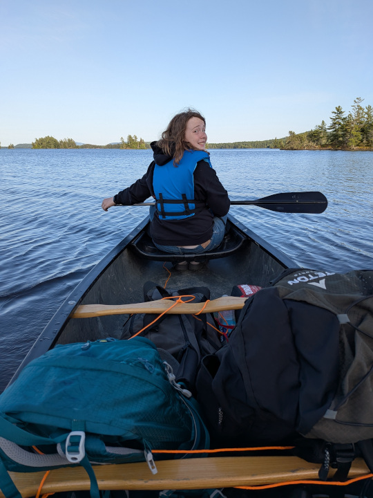
-We arrived at the park at about 2:00, and of course it started pouring while we were loading up the canoe, for just long enough to get us soaked. It lightened up while we paddled, but the wind (10 MPH steady from the NW with 25 MPH gusts) still made it as challenging as expected, and I never put down the paddle to take pictures. The wind reminded me very much of [our last trip to Grand Lake Matagamon](https://bradachorn.com/b/bsp23/), which also had a challenging paddle in, and I didn't take many pictures of that paddle either.
+We arrived at the park at about 2:00, and of course it started pouring while we were loading up the canoe, for just long enough to get us soaked. It lightened up while we paddled, but the wind (10 MPH steady from the NW with 25 MPH gusts) still made it challenging, and I never put down the paddle to take pictures. The wind reminded me very much of [our last trip to Grand Lake Matagamon](https://bradachorn.com/b/bsp23/), which also had challenging wind, and I didn't take many pictures then either.
@@ -28,13 +28,13 @@
-With all the rain I learned a few ways that I can improve the waterproofing of our equipment! In particular the supposedly waterproof compression bags that contain out summer sleeping bags are definitely not waterproof, and I threw a few things in my bag at the last minute that I completely failed to protect from water. Fortunately it mostly sopped raining after we got there, and the wind helped everything important dry relatively quickly, and the truly waterlogged items were not vital.
+With all the rain I learned a few ways that I can improve the waterproofing of our equipment! In particular the supposedly waterproof compression bags that contain out summer sleeping bags are definitely not waterproof, and I threw a few things in my bag at the last minute that I completely failed to protect from water. Fortunately it mostly stopped raining after we got there, and the wind helped everything important dry relatively quickly, and the truly waterlogged items were not vital.
-This is a snapping turtle about 16" long. It was so still we thought it might be dead, but tried to disturb it as little as possible, and when we left the area it disappeared. Based on the fresh piles of dirt behind its rear legs I think it may have been looking for a place to lay eggs. I wouldn't have disturbed it but it happened to be right next to the trail on the way down to the water and didn't see it until I was almost right next to it.
+This is a snapping turtle about 16" long. It was so still we thought it might be dead, but as soon as we left the area it disappeared. Based on the fresh piles of dirt behind its rear legs I think it may have been looking for a place to lay eggs. (We didn't disturb it on purpose, but it was right next to the trail down to the water and I didn't see it until I was almost right next to it.)
@@ -46,7 +46,7 @@
-The next morning we slept in a bit, then packed up and headed up the lake towards the Pine Point campsite. The weather was beautiful, but it was still windy enough to make paddling challenging. For about half the trip we were paddling directly into what I'd estimate were 5-10 MPH steady wind with (fortunately infrequent) 20 MPH gusts.
+The next morning we slept in a bit, then packed up and headed up the lake towards the Pine Point campsite. The weather was beautiful, but it was still windy enough to make paddling challenging. For about half the trip we were heading directly into what I'd estimate were 5-10 MPH steady wind with (fortunately infrequent) 20 MPH gusts.
@@ -62,7 +62,7 @@
-Shortly after passing the Second Lake campsite we also passed a series of 8-10 small sandy beaches similar to the one pictured below. One of them had a very old faded sign that said "Sandy Saw Beach". Unfortunately that sign is just out of frame in this picture:
+Shortly after passing the Second Lake campsite we also passed a series of 8-10 small sandy beaches similar to the one pictured below. One of them had a very old faded sign that said "Sandy Saw Beach". Unfortunately I didn't get a picture of that sign but here is one of the beaches nearby:
@@ -74,7 +74,7 @@
-The Pine Point campsite is another great looking site with a decent sized sandy beach to land the canoe at and some rocks that looked good for swimming around. However with fewer trees between the site and the water, it didn't feel quite as private as some others and I wonder how exposed it is to wind.
+The Pine Point campsite is another great looking site with a decent sized sandy beach to land the canoe at and some other rocky spots that looked good for swimming around. However with fewer trees between the site and the water, it didn't feel quite as private as some others and I wonder how exposed it is to wind.
@@ -86,7 +86,7 @@
-And looking further down the lake towards the NW tip where Webster Brook and the East Branch of the Penobscot River enter:
+And looking further down the lake towards the northwest tip where Webster Brook and the East Branch of the Penobscot River enter:
@@ -100,27 +100,27 @@
-While resting after our long paddle I checked Sunday's weather forecast and unfortunately, it wasn't good news. The thunderstorm prediction had been changed from just in the morning to any time from 10am - 4pm and while the wind was going to be variable all day, it would be mostly in directions that require a significant amount of padding against it **again**. Unfortunately Garmin doesn't give any forecast of gusts, but with storms possible I had to assume they'd be bad.
+While resting after our long paddle I checked Sunday's weather forecast and unfortunately, it wasn't good news. The thunderstorm prediction had been changed from just in the morning to any time from 10am - 4pm and while the wind was going to be variable all day, it would be mostly in directions that require a significant amount of paddling against it **again**. Unfortunately Garmin doesn't give any forecast of gusts, but with storms possible I had to assume they'd be bad.
-So out choices were to either head home now, adding an another day's worth of paddling to today's itinerary, or wait until tomorrow and risk one of the following happening:
+So out choices were to either head home now (adding an another day's worth of paddling to today's itinerary), or wait until tomorrow and risk one of the following happening:
-Of course it was technically possible the weather could be nicer than predicted, but given the way the forecast had steadily gotten worse over the last 72 hours, this didn't seem likely. In the end it just seemed foolish to take a risk that was easily preventable, and we decided to head home immediately to get back before dark. Fortunately we had not unpacked too much so we had time to finish a break and a snack and pack up and head out at about 5:30pm.
+In the end it just seemed foolish to take a risk that was easily preventable, and we decided to head home immediately to get back before dark. Fortunately we had not unpacked too much, so we had a snack and headed out at about 5:30pm.
-By this time the wind had started to calm, but we did still have a helpful tail wind for some of the paddle back. I estimated it to be a 2 - 2.5 hour paddle, which should mean getting back 30 - 60 minutes before dark, but I having never had to paddle this far in one day before and on an new part of the lake to us, I was feeling a bit anxious about getting back before dark, and paddled pretty hard.
+By this time the wind had started to calm but we still had a helpful tail wind for some of the paddle back. I estimated it to be a 2 - 2.5 hour trip, which should mean getting back 30 - 60 minutes before dark, but we'd never paddled this far in one day before and were on an new part of the lake to us, so I was feeling a bit anxious about getting back before dark at first.
-About half way back it was obvious we would easily be back an hour before dark, the wind had died down completely, and the weather overall was beautiful, making it the most relaxing and enjoyable paddle we've had in this area, especially paddling back up a glass-smooth Trout Brook. During this part Fiona and I agreed we'd definitely be coming back as soon as we can to explore more of the lake!
+About half way back it was obvious we would easily be back an hour before dark, the wind had died down completely, and the weather overall was beautiful. This was the most relaxing and enjoyable paddle we've had in this area, especially paddling back up a glass-smooth Trout Brook. During this part Fiona and I agreed we'd definitely be coming back as soon as we can to explore more of the lake!
-[](PXL_20250621_224229379.jpg)
+[](PXL_20250621_224229379.jpg)
-Overall despite it not going as planned, it was a really fun trip. There were several major challenges but we were able to overcome them all and still enjoy the lake and our time together. I also hope that deciding to head home early even though I really did not want to, because it was the responsible decision, sets a good example for Fiona to remember when she's making her own decisions. The fact that the early paddle home ending up being so enjoyable (which it definitely would not have been the next day) just ended up being a nice bonus!
+<!-- Overall despite it not going as planned, it was a really fun trip. There were several major challenges but we were able to overcome them all and still enjoy the lake and our time together. I also hope that deciding to head home early even though I really did not want to, because it was the responsible decision, sets a good example for Fiona to remember when she's making her own decisions. The fact that the early paddle home ending up being so enjoyable (which it definitely would not have been the next day) just ended up being a nice bonus! -->